Climate change and SAR
Glaciers are a key indicator of climate change effects, and nowhere else in New Zealand has more glaciers than the mountains surrounding Aoraki/Mount Cook.
We spoke to Department of Conservation staff to learn how these effects are changing the environment, their influence on visitor behavior and the impact on the planning and delivery of SAR services around our highest peaks.
Don Bogie is the Principal Advisor for Visitor Risk, and has seen huge changes over the course of his climbing and professional career.
“When I first began climbing in the 1970s, there was no Tasman Lake and access across the glaciers was pretty straightforward.”
Increased average temperatures and reduced precipitation has led to glacial down-wasting and retreat. Without the ice to support the valley walls, they begin to sag; Murchison Hut has moved nine metres downhill over the last five years.
The rock on our high peaks is relatively loose, and partly relies on year-round ice (permafrost) to hold it together. Geologists believe that the increased frequency of rain events at higher altitudes is thawing the permafrost, contributing to the instability of the terrain.
More than 30 ‘slow creep’ landslides have been identified in the area and many have the potential to release catastrophically. In the last 10 years, there have been at least four major landslides in the Grand Plateau area. Last season, there was a 700,000 cubic metres event in the Hooker Glacier area.
Ascending a major alpine peak generally involves glacier travel. In the 1980s and 1990s, climbers would wait until after the heavy snowfalls of late winter and spring which filled in the crevasses. In December, the combination of good glacial access and settled weather signaled the start of the climbing season. The season would last until April, when the warmer temperatures finally exposed enough crevasses to cut off access.
But these days, the reduced bulk of the glaciers means more snow is needed to fill the crevasses, the traditional big dumps in spring have been less reliable and the summers are earlier, hotter and drier.
Jim says visitors come much earlier in the season for better access conditions, and less harsh winters allow more frequent and bolder winter climbs. “The season [for high alpine activity] is now July to December,” he says. “We’re seeing a rapid rise in the popularity of ski touring, heli-skiing, ice climbing and winter alpine climbing.” However, the earlier season has more changeable weather and an unsettled snowpack, with avalanche hazards that are much more difficult to manage. “Last season we had 16 winter callouts, compared with two to four in preceding years.”
“The condition of the Linda Glacier route on Aoraki/Mount Cook is the reference for all snow and ice routes in the park,” says Jim Young. As leader of DOC’s Aoraki/Mount Cook Alpine Rescue Team, he has seen a significant shift of the season, even during his five-year tenure. “Nowadays, [climbing] the Linda begins in October and by early January it is cut off.”
Climate change is also influencing tramping visitors. Ball Pass was a highly popular alpine tramping loop, and each season there would be five to 10 callouts. In the huge storm of March 2019, many gullies crossing the lateral moraines washed out, making them extremely dangerous to traverse. Since then, most parties make an out and back journey to Ball Pass from the east, resulting in significantly reduced callouts.
Image: Tasman valley's highly unstable lateral moraine walls. Courtesy Don Bogie
With the Ball Pass loop off the cards, in the last five years visitor attention has shifted dramatically to Sefton Bivouac. Its proximity to the village and its stunning location is drawing many under-experienced trampers, and the number of callouts is anecdotally noted to be increasing
So what does all this mean for the planning and delivery of search and rescue in the region?
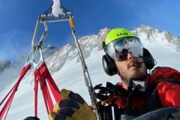
A good example is helicopter human external cargo (HEC) long-line extraction. The team have perfected the technique which minimizes rescuer exposure to highly unstable slopes. This is because more backcountry users are being caught out on walks and routes which were previously unaffected by glacial recession.

Rather than un-attaching from the long-line for a full assessment and packaging, the rescuers are more commonly remaining attached to the long-line and per forming a rapid assessment and recovery of the distressed person(s).
Image: Human External Cargo (HEC) sling load: Supplied by Jim Young
For the future, Jim and his team are discussing a proposal to slowly shift their annual rhythm of training and high-season staffing to better match the climate-induced change in visitor activity.
Elsewhere in our mountains, the impact of climate change is plainly visible. The March 2020 floods in Fiordland severely damaged tracks, destroyed Lake Howden Hut and re-routed the mouth of the Hollyford River by four kilometres. This resulted in a significant search and rescue operation, simultaneously rescuing multiple trampers who were at risk or stranded by landslides and flooded rivers.
Larger-scale search and rescue responses are becoming more common, and this has implications for capability planning within the sector. At DOC, they are working with NIWA and Geological and Nuclear Science (GNS) to model future climate effects to manage visitor risk.
Climate change is just one of the factors that the search and rescue sector must consider and adapt to. Many others are discussed within the NZSAR Environmental Scan, which gathers information about events and trends across the natural and human environments, and considers their impacts on the search and rescue sector.
The updated version of the NZSAR Environmental Scan will be published in June 2020 – this version will include new material about search and rescue in the Antarctic and the wider Pacific regions. Search “Environmental Scan” on nzsar.govt.nz
This article was first published in Link Magazine, Issue 59, June 2022.
